Cross-Section File (*.riv)
Overview
The Cross-Section Data (*.riv) contains transverse data (x and y coordinates of left/right banks) and cross-section data (distance from left bank and riverbed elevation).
Cross-Section Data should be ASCII files. Figure 483 and Figure 6‑1 show the structure and concept, respectively.
Break points of input data (for example, cross-section identification number and x-coordinate value) are identified by “space”, “tab” or “enter” characters. When break points are properly identified, iRIC automatically recognizes the data. Please note that cross-section identification number must be a real number.
Rows after the “#survey” row are recognized as cross-section data.
Each row contains data for one cross-section.
Data row: (Cross-section identification number) (x-coordinate value of the left bank) (y-coordinate value of the left bank) (x-coordinate value of the right bank) (y-coordinate value of the right bank)
Rows after the “#x-section” row are recognized as cross-section data (consisting of the “header line” and “data lines”).
Header line: (Cross-section identification number) (No. of coordinates) (Index 1) (Index 2) (Index 3) (Index 4)
Indexes 1 to 4 specify points on a cross-sectional coordinate system by sequential integer numbers. (The top is 1.) Data prior to Index 1 and after Index 4 are discarded. The point specified by Index 1 is set as the left bank and the point specified by Index 4 is set as the right bank. The points specified by Indexes 2 and 3 are to be the division points (or nodes) of the automatically created grid. The Center Point of the river is set at the point midway between Indexes 2 and 3.
You can omit Index data. In such case, all the coordinate cross-section data are read and the first point of the coordinate cross-section data is set as the left bank and the last point is set as the right bank. The Center Point of the river is set at the mid-point between the left and right banks.
When Index data are not set for every cross-section data, the index data of all cross-sections are ignored.
Data line: (Distance from left bank) (Riverbed elevation) Continue to create rows of data until there are as many rows as there are cross-sections.
Each row describes up to five sets of combinations of (Distance from left bank) and (Riverbed elevation) data.
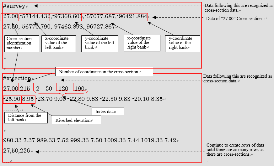
Figure 483 Structure of Cross-Section Data
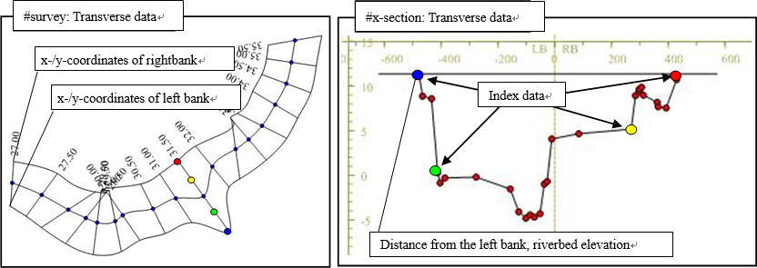
Figure 484 Concept of Cross-Section Data
Figure 484 shows the concept of the Cross-Section Data. iRIC does not display the four dots (data of Indexes 1 to 4).
The coordinates in the cross-sectional direction displayed in the [Cross-section] window have been converted as follows; note that they are different from [Distance from left bank] in the cross-section data of the Cross-Section Data.
The coordinates of the Center Point of the river have been calculated from the longitudinal data and the cross-section data.
The distance from the Center Point along the cross-sectional line has been calculated.
Note
“#x-section” line and thereafter may be omitted.
If you omit the “x-section” line and after and read only the coordinates of the left and right banks, the data will be read as cross-section data with an elevation of 0. This function is used, for example, when [Map geographic data to cross sections] is used to calculate the cross-sectional profile by interpolation from point cloud data.
CSV files for importing river center line
When importing Cross-Section Data, river center line can be imported from CSV files. Refer to Points CSV file (*.csv) for the file format.
Scheduled driver longitudinal/cross-section data creation guideline and cross-sectional Cross-Section Data
The Ministry of Land, Infrastructure, Transport and Tourism () publishes guidelines for creating the scheduled river longitudinal/cross-section data
*http://www.mlit.go.jp/river/shishin_guideline/kasen/gis/pdf_docs/juoudan/guideline0805.pdf*
Table 44 shows how to convert the Guideline data items to the River Survey Data items.
Cross-Section Data item |
How to convert the guideline data (surveyed cross-sectional numerical data) to Cross-Section Data items |
|---|---|
Coordinates of left/right banks |
Specify the coordinates of the left/right bank distance posts. |
Cross-section data |
Specify the distance of the cross-sectional coordinate data for the distance from the left bank.
Specify the elevation of the cross-sectional coordinate data.
|
Index data |
Set as follows:
Index 1: Number that corresponds to the left bank distance post
Index 2: Number that corresponds to the left bank shoreline post
Index 3: Number that corresponds to the right bank shoreline post
Index 4: Number that corresponds to the right bank distance post
|